Author: Jessica Leigh Hester / Source: Atlas Obscura
The weeks and days before the Chinese space station’s imminent reentry into Earth’s atmosphere have been busy ones for Marco Langbroek.
He’s a trained archaeologist and a passionate amateur satellite tracker, and his followers want to know when and where Tiangong-1 will chart a fiery course through the sky. In pursuit of an answer, he’s logged long stretches at his computer in the Netherlands, fiddling with predictions about what’s going on up there.One thing’s for sure: The space station is falling. Tiangong-1, which launched in 2011, stopped communicating with ground control in March 2016. With no way to bring it down into a controlled descent, scientists have only been able to wait for its orbit to decay. It’s expected to tumble to the ground or ocean sometime in the next few days.
Both amateurs like Langbroek and government agencies want to figure out where and when it will arrive. For weeks, Langbroek has been posting daily forecasts on Twitter and his blog. His mission is both aesthetic and logistical. Like a meteor, it could leave a remarkable streak across the sky; if the weather cooperates, anyone in the vicinity will be able to see it with the naked eye. And when it touches down, any pieces that weren’t incinerated will need to be found and possibly repatriated to China. (Under the Outer Space Treaty of 1967 and the 1972 Convention on International Liability for Damage Caused by Space Objects, anything falling from space is the property of the country that put it up there.)

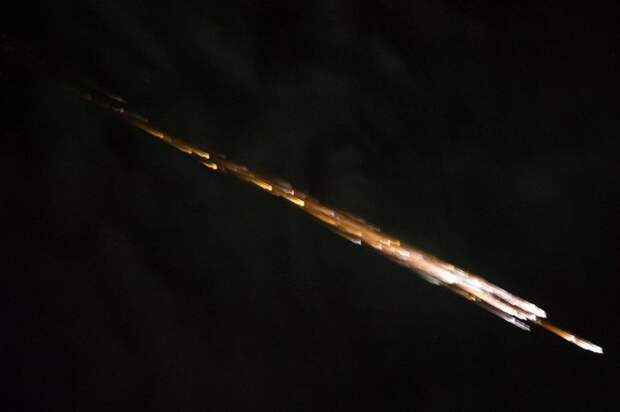
Predicting its path and crash site is no simple task. There’s a lot of data to wrangle, and some wildcard variables, such as the thickness of the atmosphere where it enters, which can change with little warning (as the result of a solar flare, for instance). Tiangong-1 itself is a variable, because while its surface area is known, the oblong space station could be spinning, and its drag will be affected by its orientation. Without detailed images, it’s hard to know for sure which end is coming down first.
Depending on whom you ask, these unknowns are either a headache or fuel for the chase. Langbroek gets a kick out of them. Each day, he pulls raw orbital data from the Joint Space Operations Center tracking network. He also uses the free programs SatAna and SatEvo, and a model atmosphere from NASA to forecast time and location. He often models multiple scenarios—adjusting for different orientations, for example. Even so, as late as Wednesday evening, the geographic estimate for Tiangong-1’s reentry was vast—spanning thousands of miles and multiple continents.
The lines on this map are where #Tiangong1 can come down within the current +- 1-day uncertainty window.
Cities with populations > 1 million people are also marked on the map, and those on the lines could see a reentry over them. The risk to these cities is however *very small* pic.twitter.com/QFnoLx1dbV— Dr Marco Langbroek (@Marco_Langbroek)
As the orbital decay continues, the estimated time and…
The post Meet an Amateur Astronomer Tracking the Falling Chinese Space Station appeared first on FeedBox.