Source: WPXI


PITTSBURGH – A line of strong storms moved throug the area Sunday night, leaving thousands of people without power.
-
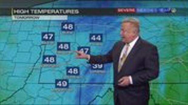
Cooler temps, snow showers possible Monday -
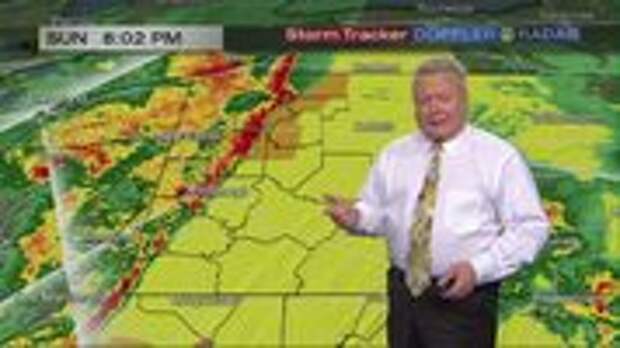
Severe Weather Team 11 update (8:05 p.m.) -

Meteorologist Kevin Benson’s extended forecast (4/14/19)
UPDATE 11:30 p. m.
Strong storms are moving out of the region, but much colder air is moving in for Monday.
Wind gusts up to 30 mph are possible.
A few rain and snow showers are in the forecast.
If you want to receive ALERTS about weather, please download our WPXI News App.
UPDATE 11:20 p.m.
East Willock Road is closed at the intersection of Doyle Road in Baldwin because of flooding.
E Willock Rd is closed at the intersection of Doyle Road in Baldwin because of flooding stay with @WPXI for when the road will reopen. pic.twitter.com/kVq1lJuBGn
— Jamie Cashdollar (@Cashmoney2292)
UPDATE 10:28 p.m.
As of 9 p.m., Duquesne Light was reporting over 2,300 outages. First Energy was reporting over 4,000 outages in our area.
UPDATE 9:56 p.m.
A Tornado Warning has been issued for Indana County until 10:15 p.m.
WEATHER ALERThttps://t.co/pmwncDzuHb | https://t.co/5TuINuXud7 | https://t.co/jMjzNKJQ6v | https://t.co/kXBEdLY2tR pic.twitter.com/qUJOWJRygk
— WPXI (@WPXI)
UPDATE 9:49 p.m.
A Severe Thunderstorm Warning is in effect for Indiana County until 10:15 p.m.
UPDATE 9:14 p.m.
More counties have been dropped from the Tornado Watch.
Indiana, Fayette, Jefferson and Westmoreland counties remain under the watch.
UPDATE 9:00 p.m.
Thousands of people in our area are without power.
As of 9 p.m., Duquesne Light was reporting over 1,500 outages. First Energy was reporting over…
The post Storms moving out, cold air moving in appeared first on FeedBox.