Author: Hans Harmsen / Source: Atlas Obscura
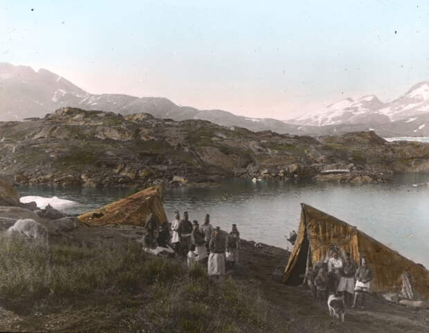
On September 1, 1884, Danish explorer Gustav Holm and his men set ashore at the small settlement of Ammassalik (“the place with capelin”), on the eastern coast of Greenland. They had traveled for four months, from the trading post of Nanortalik in the south, in a small armada of seal-skin boats and kayaks.
Johannes Hansen, a translator on the expedition, recalled that day’s first meeting with the local Tunumiit people in his diary, “… sometimes they lined up quite far away from us and stared at us, and yelled îh and âh; and then someone said, ‘We are sorry for you poor things, for having come this long way up to our dismal land; but to us you are incredibly funny, and pleasing to look at!’”The Tunumiit knew of the Danish missionaries and traders to the south, but very few had actually seen a European before. These East Greenlanders didn’t know it, but Holm’s arrival heralded the eventual end of a way of life going back a millennium. The meeting also generated some of the most well-known, unusual, and misunderstood artifacts from the Inuit world.
Accounts describe Holm as a quiet, reserved, inquisitive man with a steadfastness hardened by years of naval service. His mission was exploratory, backed by the Danish Commission for the Direction of Geological and Geographical Investigations in Greenland, to gather as much information as possible about this unforgiving stretch of coastline, known for violent storms and impenetrable ice fields. There also appears to have been some interest among the Danish colonial administration at the time to see if any long-lost Norse colonies had somehow survived the centuries, hidden away along the northern reaches of the eastern coast.
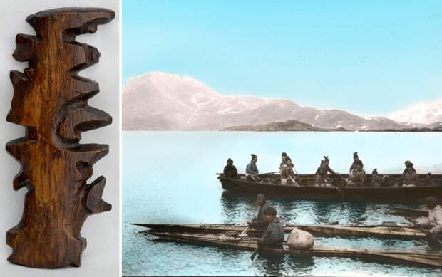
Holm had a keen appreciation for Inuit boat design—a good instinct in an environment only the locals understood well—and was using the traditional Inuit seal-skin umiaq, which allowed him and his crew to move safely and swiftly through dangerous fog and brash ice. In addition to three Europeans tasked with charting the terrain and making scientific observations of weather and geology, the crew was made up of about 30 Greenlanders from the south, who navigated, rowed, did the heavy lifting, and provided a steady diet of seal meat. A few were on hand to act as translators and missionaries as well.
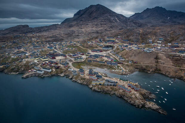
After Holm arrived in Ammassalik, today a town known as Tasiilaq, it was clear that the coming winter would prohibit safe passage back south, so the expedition decided to settle in for the next few months. This layover gave Holm the time he wanted to build relationships, as well as document the customs, language, and stories of the Tunumiit. Trade of goods is the currency of goodwill in many of these cultural exchanges, so Holm had brought European ironware, fabric, tobacco, and beads, which he bartered for anything and everything he could get his hands on. By the end of the winter, he had collected about 500 objects, from traditional clothing, hunting and fishing gear, and furnishings, to toys, magical talismans, masks, and ritual objects. To this day, much of the knowledge of traditional East Greenlandic art and handicrafts is informed by this collection.
At the same time, Holm was focused on mapping the coast and filling huge gaps in knowledge of the coastline’s geography. This was a foreign practice to the Tunumiit, who had a different way of seeing the world. For these seafaring people, geographic knowledge was something remembered and shared through stories and conversations of travels and hunting. “The drawing of charts and maps,” Holm wrote, “was of course quite unknown to the people of [Ammassalik], but I have often seen how clever they were as soon as they grasped the idea of our charts. A native from Sermelik, called Angmagainak, who had never had a pencil in his hand and had only once visited the East coast, drew a fine chart for me covering the whole distance from Tingmiarniut to Sermiligak, about 280 miles.” They also provided him with incredibly detailed descriptions of terrain, flora and fauna, and, in some cases, local weather patterns and…
The post Greenland’s Hand-Sized Wooden Maps Were Used for Storytelling, Not Navigation appeared first on FeedBox.