Author: Jessica Leigh Hester / Source: Atlas Obscura
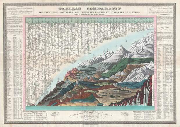
The cooled lava, ash, and pumice of the Cotopaxi volcano climb to more than 19,300 feet. The volcano, part of the Pacific Ring of Fire, is near Quito, Ecuador—clear across the globe from 26,800-foot Dhaulagiri and its dozens of Himalayan cousins in India, Nepal, and Bhutan.
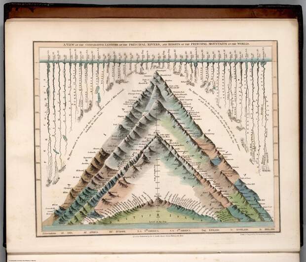
But if you had only J. Andriveau-Goujon’s atlas from 1829 to go by, you’d be forgiven for thinking otherwise. On a single plate, Cotopaxi and its billows of gray smoke sit right below Dhaulagiri’s snow-capped summit. This image, and many others like it, cast longitude and latitude to the wind. On it, altitude is king.In the 19th century, cartographers had a penchant for plotting some of the world’s tallest peaks together on single charts. The results were imaginary landscapes; some placed all of the world’s mountains into a single, massive range, while others evoke cross-sections, with the mountains stacked inside one other like geological nesting dolls.
Matthew Edney, a geographer at the University of Southern Maine, attributes the style’s popularity to a few factors—particularly poets swooning over the natural world, and the dash to measure and document it.
Thanks in part to the Romantic writers, in the 19th century mountains were shifting in the cultural imagination, from places to be avoided to landscapes calling out to be traversed, even if they remained sources of fear. William Wordsworth was a bard of slopes and summits. He traipsed through the Alps, and in The Prelude, described scaling Snowdon, in Wales, through thick clouds:
I found myself of a huge sea of mist,
Which, meek and silent, rested at my feet:
A hundred hills their dusky backs upheaved
Meanwhile, scientists were doubling down on Humboldtian science, named for Alexander von Humboldt, a German naturalist who liked mountains and never met something he didn’t want to quantify. His principles involved “going out and measuring everything you can about the natural world, and then from there figuring out some rules of nature,” Edney says.
Humboldt proposed spatial dynamics to natural laws—noting, for instance, that altitude, not just distance from the poles, affects the distribution of plants. In the Andes, he documented that the plants growing at various…The post The Fantasy Maps That Put the World’s Tallest Mountains Side by Side appeared first on FeedBox.