Author: Matthew Cappucci / Source: Science News for Students
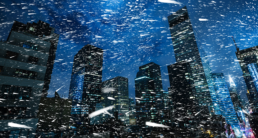
Heavy snow can often create a peaceful setting. A blissful quiet may develop as snowflakes drape the landscape beneath a blanket of white.
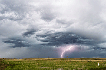
But occasionally, a sky-wide flash can disrupt this tranquility with a deafening, ear-splitting crash. That sound can echo, briefly, like gunshots. The ground may even shudder.This is thundersnow.
To occur, the circumstances have to be exceptional. And unless it occurs almost directly overhead, you may never know it. The reason: Snow acts as a sound suppressor, muffling thunder and limiting the sound’s ability to bounce and spread.
Yet thundersnow appears to be getting a bit less rare.
For instance, a huge March 7 nor’easter snowstorm hit the Northeast states and New England earlier this week. And it was accompanied by numerous cracks of thunder. One bolt even struck New York’s tallest structure, the new 104-story World Trade Center building.
Two months earlier, another epidemic of thundersnow punctuated New England skies. It arrived shortly after daybreak on January 4, 2018. On that morning, a flurry of more than 30 flashes hit an otherwise quiet, wooded area in Montville, Conn. They occurred along a narrow band on the northwest side of rural Lake Konomoc.
Lightning mapping is accurate to within a few hundred meters (up to 1,000 feet). So it’s impossible to confirm with only those data what got struck.
But there are two radio- and television-transmission towers in nearby Oakdale that soar some 316 and 367 meters (1,037 and 1,204 feet) into the sky. A limousine company — Liberty Limited — is right next to the property on which these towers sit. Angela Ried works for that limo company. And she confirms the towers were struck that day.They “got struck at least four or five times,” she recalls. “It was pretty loud.” Though she knew at once it was lightning, she was surprised to hear it in winter. “I’ve worked here since ’93,” she notes, “and this is the first time I’ve ever seen thunder and lightning during a snowstorm.”
Her memory matches lightning reports logged by the National Weather Service.
Thundersnow also moved into Needham, Mass. Lightning was registered at sites near the WCVB-TV transmission towers. These structures rise some 395 meters (1,300 feet) into the air. They too sparked off about a dozen lightning strikes.
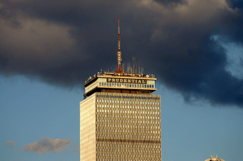
In nearby Boston, only one building got struck. It was the Prudential Tower, a 52-floor skyscraper with a rooftop spire topping 276 meters (906 feet). The mast broadcasts signals for multiple radio stations. “I heard it,” said Owen Anastas, of Boston. This particular strike, he notes, “happened around 11:30 during an incredible snow.”
The storm dumped a foot (one-third meter) or more of snow throughout a wide swath. And an estimated nine in every 10 lightning strikes in that storm struck man-made structures more than 250 meters (820 feet) tall. That raises the question: Are human structures playing some role in fostering thundersnow?
What makes thundersnow?
Thunderstorms usually form when warm air near the ground rises (because it is less dense than nearby masses of cold air). It’s the same reason a hot air balloon soars. And these conditions are why most boomers are spawned during spring and summer months.
The climbing air will rise several kilometers (miles) up, to a height where the temperature is below freezing. This can trigger a phenomenon called triboelectrification (Try-bo-ee-lek-trih-fih-KAY-shun). This word describes friction among air particles that causes a separation of electrical charge. It’s somewhat like rubbing a balloon against fabric so that the separated charge now allows the balloon to temporarily “stick” to the wall.
Air within the thunderstorm is very turbulent. This causes ice crystals to bump into each other. Through this process, they can gain or lose electrons. Ice crystals lose electrons, leaving them positively charged. Wetter precipitation gains electrons, making it negatively charged. When the charges build up enough — ZAP! An electric spark, or lightning, jumps between the two regions to balance out the charge.
To get this in the wintertime, however, is challenging. In the summer, pockets of air rise vertically to produce thunderstorms. That doesn’t really happen in the winter. Frigid-weather storms develop differently.
Two conflicting forces wage a battle that sends air on a “slantwise” path high into the sky. That means the air isn’t rising straight up and down, as in most thunderstorms. Thundersnow storms also do not usually form on the warm side of large, spiraling cyclones, as thunderstorms typically do. Instead, they develop in a weird spot – the colder backside of the storm system.
Because large storm systems oftentimes look like commas, that aggressive backlash is called the “comma head.” This is where cold air wraps in from the north.
Snowstorms can become super windy. This will happen because the lowest air pressure will occur at the center of the storm. It mimics a vacuum, pulling in air from its surroundings. Air spirals into the middle of storm systems like water swirling down a drain.
Or this is what usually happens.
But the January 2018 storm threw a meteorological curveball. It brought with it an extremely strong temperature gradient. Over the ocean waters off of Cape Cod, Mass., air temperatures soared to near 13° Celsius (55.4° Fahrenheit). Just 330 kilometers (205 miles) to the west, over land in Connecticut, it was 18 degrees C (23 degrees F) colder.
That extreme temperature contrast over such a narrow region generated a thermal wind. That’s when air flows from warm to cold regions.
Since cold air is denser; it sinks to the ground. Warm air from the ocean gets pulled in to replace it. That surface-hugging cold air undercuts the encroaching warm air. So the warm air now sloshes up that cold “surface” of air.
That warm air goes on to climb into the atmosphere because it has so much momentum. It’s like rolling a ball up a slide. Here, the slide is the surface of cold air. And the warm air is that ball rolling up that surface. Normally, the air wouldn’t take this path. It’s like bowling the ball up the slide, against the force of gravity.
It’s also fairly uncommon, which makes it tough to forecast. It is much easier to predict the conditions that tend to be associated with it, such as narrow bands of heavy snow.
Figuring out if, when and where lightning will strike within a snowstorm is a different story.
The National Lightning Detection Network is a commercial array of antennas across the United States. It monitors lightning strikes 24/7, all year long. But this network’s antennas will miss bolts that flash within clouds. That’s why the National Weather Service relies on public reports of thunder or lightning to track most thundersnow.
On rare occasions, as occurred earlier this winter, bolts may strike the ground. And when they do, these can be just as dangerous as strikes during a summer storm. They can cause damage, injury — even death. One bolt during a snowstorm on February 9, 2017, caused a house fire in Warwick, R.I. The bolt also zapped a nearby tree, blasting part of its trunk into the wall of that home,
The link to human activities
So what’s going on? Two Japanese researchers had some insights 24 years ago that they described in the Journal of Geophysical Research. Their paper reviewed decades’ worth of wintertime lightning strikes off the north coast of Japan. The pair used radar data and measurements from instruments used to measure electrical activity. From these data, clues emerged. It appeared that a key change takes place when low-topped winter thunderclouds mature.
Think of the cloud as a three-layer cake, with each layer having a different electrical charge. For shallow, low-topped winter thunderclouds, the charges in these layers are positive-negative-positive. The lower positive charge can appear at temperatures from 0 to -9° Celsius.
And where the lower layer has a net positive electric charge, that layer “is apparently capable of initiating ground flashes,” the paper noted.
So why did the 2018 New England storm clouds almost exclusively throw their lightning at tall towers?
It’s possible that these towers triggered the lightning by poking into the underside of clouds. In doing so, they take on this lower positive charge. They can now spark a bolt between the now-positive tower and the negative charge in the middle of the cloud above.
But that alone shouldn’t be enough to generate a bolt. After all, the electric fields in snowstorms are significantly smaller than those in summer thunderclouds.
However, those fields can be locally enhanced by pointy objects. Those points can focus a charge, boosting it 10-fold. And that may be enough to exceed the level required for an electric charge — or spark — to leap through the air. Once…
The post Explainer: What is thundersnow? appeared first on FeedBox.