Source: NJ.com
It’s starting to feel like a rerun of last week, and a rerun of many other storms that have pestered New Jersey this winter.
Another storm system is heading our way on Wednesday and — like so many others before this — it will be bringing a sloppy wintry mix of snow, sleet, freezing rain and plain rain.
Just like the storm that hit us last Tuesday, big snowfall totals are not in the cards for New Jersey. However, forecasters are concerned about hazardous driving conditions because of the mixed precipitation.
Their biggest concern is focused on the Wednesday evening commute, when many areas of the Garden State are forecast to have a light coating of snow on the ground, with sleet and freezing rain mixing in as temperatures rise from the low 30s to the mid-30s.
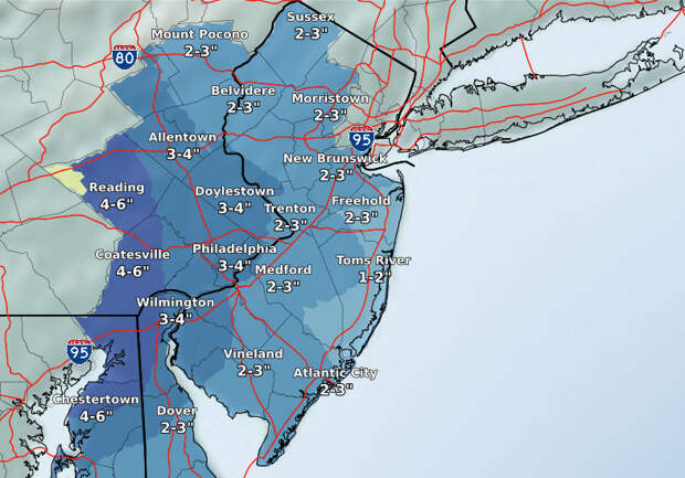
Here’s what drivers can expect on Wednesday, based on the latest forecast from the National Weather Service.
- Light snow should start falling in the southwestern region of New Jersey by 8 a.m. or 9 a.m. Wednesday and become more steady in the late morning.
- Snow is expected to spread into central counties in the late morning and up into northern counties in…
The post N.J. weather: Sloppy mix of snow, sleet, freezing rain could make driving tricky on Wednesday appeared first on FeedBox.