Author: Jessica Leigh Hester / Source: Atlas Obscura
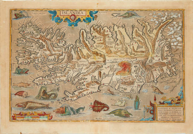
There’s a lot to look at in Abraham Ortelius’s map of Iceland. The Antwerp-born mapmaker, who compiled the Theatrum Orbis Terrarum, regarded as the earliest modern atlas, was also among the first to annotate the country in considerable detail.
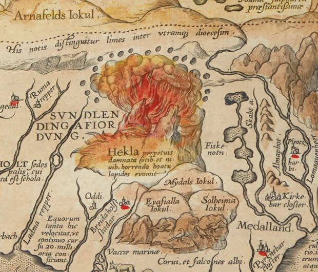
Building upon the work of Andreas Velleius and Gudbrandur Thorláksson (Guðbrandur Þorláksson), an Icelandic mathematician and bishop, the geography of Islandia is vivid. Look for the vast network of settlements, fjords, and mountains. Wander toward the center of the engraving, then south, and you’ll find Hekla, the volcano; mid-eruption, it spews forth an angry torrent of red and orange.Iceland being an island, much of the chart is made up of water. That’s where you’ll find pearlescent shards of ice on the top right, bobbing beneath packs of loafing and wrestling bears. Here also be fractured tree trunks and branches, bandied about by the waves, and blobs of spermaceti floating like oily icebergs.
And, of course, much of the water is home to a marvelously oddball menagerie. Many of these creatures are native to other maps. Ortelius explicitly invokes Olaus Magnus, who had, just a few decades earlier, drawn one of the earliest detailed maps of the Nordic world, with waters full of toothed, sharp-tailed creatures. (Another common go-to guide for sea-dwelling scaries was a chart by Sebastian Münster, whose bestiary evolved from Magnus’s.) The striped fish with a bulbous, fringed head, busily devouring a seal (labeled “E” on Ortelius’s map), looks much like Ziphius, a creature on Magnus’s map, which was called the Carta Marina. Ortelius notes that he looked to Magnus for inspiration for the hyena (or sea-hog), too, borrowing its porcine snout and furry fin.
A massive crustacean, with a flailing human in its clutches, apparently didn’t make the cut.These sea beasts weren’t only there to horrify or delight….
The post For Sale: A 16th-Century Map of Iceland, Roamed by Fantastic Beasts appeared first on FeedBox.