Author: Cara Giaimo / Source: Atlas Obscura
Joseph Jacinto Mora knew all the dogs in Carmel-By-The-Sea, California. He knew Bess, a friendly brown mutt who hung out at the livery stables. He knew Bobby Durham, a pointy-eared rascal who, as Mora put it, “had a charge [account] and did his own shopping at the butcher’s.
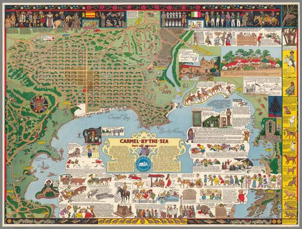
” He knew Captain Grizzly, an Irish terrier who went to town with his muzzle on and invariably came back carrying it, having charmed a kind stranger into taking it off.If you spend time with Mora’s map of the town—which was first printed in 1942—you’ll know the town dogs of that era, too. They’re all stacked in a column on the right side, lovingly described and illustrated, and looking as natural as those items you’d be more inclined to expect on a map: streets, land masses, the compass rose. On this particular map, those elements aren’t so typical either: the streets are strewn with tiny houses, and both the land and sea are peppered with busy people. The compass rose is rotated 90 degrees counterclockwise, and—as befits an artist’s town—is helmed by a painter, a performer, a writer, and a musician.
Such is the way of a Jo Mora map. Over the course of his life, the “Renaissance Man of the West,” as some have called him, packed history, geography, and personal details into a series of maps of different parts of California. Although well-known in his time—“Mora has produced works of art which have told their story to more persons, probably, than have the works of any other Californian,” columnist Lee Shippey wrote in the Los Angeles Times in 1942—he has largely fallen out of the public consciousness. But a few minutes with one of his maps plunges you back into his era, and his own worldview.
Mora was born in Uruguay in 1876. When he was four years old, his father, the sculptor Domingo Mora, moved the whole family to Massachusetts. He went to art school in New York City—a place full of “precipitous sided canyons and underground burrows,” he later wrote—and worked as an illustrator for the Boston Herald, drawing scenes from the day’s news.
Throughout, “he was really curious about the American West,” says Peter Hiller, the Collection Curator of the Jo Mora Trust, and the author of an upcoming biography of Mora. Even as he was getting his degree and amassing an East Coast portfolio, he was spending long stints on the other side of the country. He worked as a cowboy in Texas, and rode on horseback from Baja, Mexico up to San Jose. He lived in a Hopi and Navajo community for two-and-a-half years, learning to speak both languages, taking photographs, and painting precise watercolors of Kachina dances. By 1907, he had officially moved to California, settling in Mountain View with his wife, Grace Alma Needham.
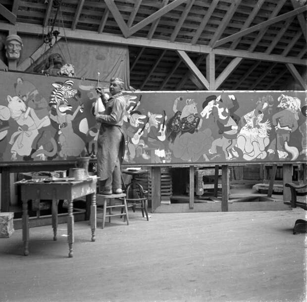
Over the course of his career, Mora explored a number of different mediums, including sculpture, painting, and coin design. “It’s almost easier to list what he didn’t do,” says Hiller. But beginning with his first published map—of the Monteray Peninsula, commissioned as part of a local history book—cartography came particularly easily to Mora. “I’ve had this feeling from talking to Jo’s son Joey that [the maps] were almost spontaneous,” says Hiller. He would sketch a draft out in pencil, and then redraw it in black ink, on a large, heavy board. It would then…
The post The Cowboy Cartographer Who Loved California appeared first on FeedBox.